Geological underpinnings of the Modern Mississippi Delta
On May 8, 1541 the expedition of Hernando de Soto encountered the Mississippi River near the current site of Memphis. At the time the mouth of the river was just west of Grand Isle. The modern “birdfoot delta” had not yet been formed. The earliest navigational charts of coastal Louisiana postdate the inception of the latest delta lobe, so the timing is not certain. It is likely that the river avulsed to a new course directed toward what is now lower Plaquemines Parish some time in the 18th century. For the previous 4,000 years or so that river had changed is course roughly every 500 years. These changes or the patterns of the delta lobes that they created were not random. The river sought out accommodation capacity for its sedimentary load with the efficiency of a living organism.
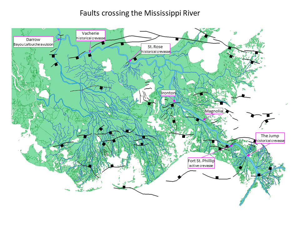
Accommodation capacity in a delta is a direct function of subsidence. For a delta lobe to have stayed in one place over the 500-year span that it took to develop, the geological structure of the area had to be able to give way to the accumulating sedimentary load. A recreation of the history of delta lobes in southeastern Louisiana by David Frazier shows that the river methodically sought out the salt and fault basins. The river tended to settle on sites underlain by geological synclines generally bounded by conjugate pairs of faults that down-dropped to the center of the syncline.
Since the time of the Pyramids of Giza the river repeatedly returned to the elongate syncline called the Terrebonne Trough that runs beneath the coast of Louisiana. Over time the accumulated thickness of the Holocene delta sediments revealed the shape of the Terrebonne Trough with its bounding conjugate faults. At the eastern end of the trough the alignment of the faults and the axis of the sedimentary thick takes a distinct turn to a more north-south orientation. This is the portion of the syncline sought out and occupied by the Mississippi River some time in the 18th century.
The fault and salt map of the area represents the salt domes with colors indicating the depth to top of salt. The warmer colors indicate shallower depths. The large Lake Washington dome in the northwest corner rises up to about 2,000 feet below the surface. The major faults that reach the surface are represented by fault plane contour maps. The blue surface fault traces coincide with the 0-depth contour of the fault plane. The basin occupied by the modern delta is bounded by salt domes on its east and west sides. The Bastian Bay, Main Pass and Garden Island Bay faults arc around the northern and eastern flanks to form very distinct boundaries. At depth these faults are matched by conjugate sets of faults that create a graben structure. These faults can be seen in profile view, but they do not extend to the surface and are not represented on this map. The central axis of the graben clearly parallels the bounding faults to the east.
The river found maximum accommodation capacity along the central axis of the graben. The course of the main channel is straight across the center of basin directly overlying the graben axis. It appears that the tri-furcation of the main channel at Head of Passes occurred where the main channel encountered the down to the north Head of Passes fault. Faults have been documented to have bathymetric expression at the surface in this area. It is possible that an escarpment on the bottom of the channel caused by this fault could have provided enough resistance to flow to cause the river to separate its flow.
Two profiles across the basin reveal the geological underpinnings. Profile 1 crosses the large Main Pass fault. It can be seen extending to a depth of about 27,000 feet below the surface where it meets a smaller conjugate fault. Together they form the central graben. Sediments in the Upper Miocene, Pliocene and Quaternary are clearly thicker on the downthrown side of the Main Pass fault indicating that it has been continually active throughout that time. The graben probably formed some time in during the Lower Miocene, and offset the underlying Paleogene sediments. In the early stages of fault movement, the lateral component can be greater than the vertical component. The lateral component of slip on the faults in this graben caused the Paleogene section to be offset to the extent that the central axis of the graben is defined by a belt in which no Paleogene section is found. This belt directly coincides with the course of the main channel of the river.
Profile 2 crosses the Garden Island Bay fault. The similarity in orientation and growth history of this fault with the Main Pass fault indicated that they are genetically related, but they are not the same fault. As can be seen on the fault plane map, the contours do not connect.
Three dimensional renderings of the delta show the relationships between the channels, lobes and faults from two different perspectives. The first one from the northwest shows the main channel running parallel to the bounding faults of the central graben. It also reveals how the channel spread out when it encountered the Head of Passes fault.
The perspective from the southwest suggests a relationship between faults and each of the main sub-lobes/channels on the east side of the delta. There is an undeniable relationship between the architecture of the delta and the subsurface geological structure.
Andrew Tweel and Eugene Turner at LSU’s College of the Coast and Environment studied the relationships between watershed land use, river engineering, wetlands formation and wetland loss in the Mississippi River delta. In a 2012 study they reported an anthropogenically driven increase in mean suspended sediment concentrations in the Mississippi River below New Orleans between the end of the 18th century and late 19th century, followed by a sharp reduction, and then a period of stabilization after 1962. The rise of agriculture across the Mississippi River watershed in the 18th and 19th centuries, and the inefficient practices associated with it caused an increase in erosion and a dramatic rise in the suspended sediment load of the river. By the early part of the 20th century engineering of the river including levees, locks and dams reversed that dramatic rise.
Tweel and Turner noted importantly that “The rapid growth of the Mississippi River birdfoot delta until the 1930s, which has been used as a reference for one of the world’s largest wetland restoration efforts, may not be a suitable archetype for the majority of the coast.” In other words the patterns and rates of land area growth in the modern delta were substantially impacted by anthropogenic factors, and are not indicative of the natural patterns and rates associated with deltas prior to the European occupation of North America.
Navigational charts from 1838 forward have allowed for a reasonable reconstruction of the modern delta of the Mississippi River in ten-year increments. This reconstruction suggests the relationships between the patterns of formation of the delta and the underlying geology, as well as the influence of changing sediment supply throughout the time span.
REFERENCES
Frazier, D.E., 1967, Recent deltaic deposits of the Mississippi River: their development and chronology, Trans. G.C.A.G.S., v. 17, p. 287‐315
Tweel, A. W. and Turner, R. E., 2012, Watershed land use and river engineering drive wetland formation and loss in the Mississippi River birdfood delta, Association for the Sciences of Limnology and Oceanography, v. 57, p. 18-28


