The Vacherie fault
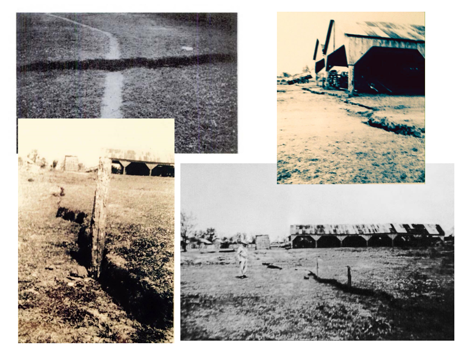
At 2:00 o’clock in the morning on April 12th, 1943 a fault ruptured the surface of the earth at a sugarcane plantation along the west bank of the Mississippi River near Vacherie, Louisiana. Given that it was spring, the river was at medium flood stage, and the north end of the fault was only about three-tens of a mile from the levee, the New Orleans District of the Corps of Engineers dispatched Harold Fisk to investigate. Fisk was an Associate Professor of Geology at LSU and was putting the finishing touches on his seminal work GEOLOGICAL INVESTIGATION OF THE ALLUVIAL VALLEY OF THE LOWER MISSISSIPPI RIVER. He found that the surface rupture was composed of a series of parallel open cracks arranged in an en echelon pattern. Together they were over a mile long, on an orientation of about 30 degrees west of north, and the western side of the fault was down-dropped relative to the eastern side. There as a maximum displacement of about eight inches near the center of the fault trace.
This episode brought together three seemingly disparate timeframes of geological history. The movement of the fault was an instantaneous geological event. Fisk’s investigation would show that the fault had probably been moving episodically for centuries. Later exploratory drilling would find that this same fault was a critical structural component of the Vacherie oil field and had been moving interactively with the Vacherie-Hester salt dome for millions of years. Most people tend to think of geological processes in terms of things that happened over long periods of time in the distant past. It is not until the occurrence of an instantaneous event that we consider the implications of geology in the here and now. The importance of the Vacherie fault rupture is that it shows that studying geological processes in the past is the best way to predict and prepare for the occurrence of instantaneous (and potentially catastrophic) events in the future.
Exhibit 1 of Docket No. 76-432 at the Geological Oil and Gas Division of the Louisiana Office of Conservation includes a subsurface structure map and fault plane map submitted as evidence in a unitization proposal filed at Vacherie Field. The outline of an approved geological unit determines the ownership and revenue sharing of the oil and gas production from the unit. The subsurface structure map on the Hurley Sand shows a gas reservoir (colored red on the map above) in a wedge-shaped structural trap between two faults on the southwestern flank of the salt dome. The depth of the reservoir sand below the surface is indicated by the values of the contour lines, which can be read like a subsurface topographic map. The fault traces at this horizon are colored light brown and the triangles indicate the downthrown direction. The fault plane map on Fault “C” shows the connection between the deep geological fault that forms the trap in the 20 million-year old gas reservoir and the surface trace that ruptured in April of 1943. The values labeled in black next to the well symbols indicate the depth at which the fault plane crosses each well. “Picking fault cuts” on well logs is an element of basic subsurface geological interpretation. The vertical displacement on Fault “C” is measured to be 700 feet at a depth of 7,100 feet near to the dome. Displacement progressively decreases at shallower depths until it reaches the value of 8 inches measured by Fisk on the surface rupture.
The most significant of Fisk’s findings was that the fault rupture line appeared to coincide with the channel of the historical crevasse of the Mississippi River at Vacherie. It is reasonable to conclude from this coincidence that the crevasse of the river was caused by an episode of fault movement at some time in the past few centuries. This episode would have caused a surface rupture that did reach the channel of the river causing the crevasse to occur. Fisk took a series of sediment borings across the fault to construct a profile of the Holocene and upper Pleistocene sedimentary layers. Section A-A’ shows that the Holocene strata are offset by the fault, and Fisk measured 3.5 feet of displacement in the upper Pleistocene. If this displacement represents the total offset caused by episodes of fault movement during the Holocene and each episode contributed the same 8 inches of offset as the most recent episode did, then it is logical that there were five or six episodes of fault movement during the Holocene. The overall size of the topographic ridge that extends from the point of crevasse to Lake Des Allemands and the relative complexity of the crevasse channel network suggests that they may be the result of multiple crevasse events during the late Holocene.
It is important to note that the movement of this fault did not create a seismic event that was detectable at the seismography station at Loyola University about 50 miles away. This would suggest that movement experienced at the surface was not directly associated with deep tectonic movement. Understanding the processes associated with this type of aseismic or “slow slip” fault movement is likely to prove to be very important to gaining a broader understanding of fault movement in south Louisiana in general. In the particular case of the fault at Vacherie one possibility may be the dissolution of the Vacherie-Hester salt dome. Brent Bray and Jeff Hanor of the LSU Geology Department studied pore water salinities in the vicinity of the dome and found a significant plume of hypersaline fluids emanating from the salt stock. They concluded that this plume indicates that salt is being dissolved and migrating away from the dome along faults. Hanor has found this phenomenon at multiple salt domes across south Louisiana and he has estimated that in total several cubic kilometers of salt has been lost to dissolution. The dissolution of salt creates an obvious space problem in the subsurface, and it may be possible that fault movement around these domes is in part a response to salt dissolution.
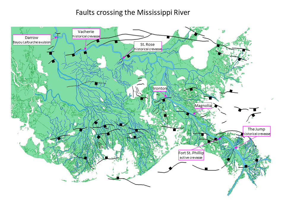
The map below shows several places where surface fault traces appear to intersect the channel of the Mississippi River. Surface fault traces are shown in black with squares indicting the downthrown direction of the main faults. These traces represent the current state of a compilation of published works (Armstrong et al, 2014; Gagliano et al, 2003; Dokka, 2011; Kuecher et al. 2001) and an active, on-going interpretative process involving research at UNO, Tulane and ULL (Akintomide et al, 2019; Bullock et al, 2018; Frank, 2017; Johnston et al, 2017; Levesh et al, 2019). The map also reflects compilations of research funded by the RESTORE Act Centers of Excellence, the TranSET transportation consortium and the Louisiana Department of Transportation and Development. Access to the oil and gas industry seismic data used in the university research has been coordinated through the Louisiana Geological Survey Coastal Geohazards Atlas project. In addition to Vacherie, sites at Darrow, St. Rose, Fort St. Phillip and The Jump are associated with historical crevasses or avulsions, or in the case of Fort St. Phillip, an active crevasse that formed in 1973. Surface fault traces also appear to intersect the river at Ironton and Magnolia.
The potential for the movement of faults that intersect the channel of the Mississippi River is an obvious area for more research. The first objective should be to get a complete and accurate map of all surface fault traces near the river. The publication of a complete and accurate map of surface fault traces is one of primary objectives of the LGS Coastal Geohazards Atlas project. In order to achieve this objective, it will be necessary to adequately fund the Atlas project and to negotiate a more comprehensive data-sharing arrangement with the oil and gas industry. This should be a priority for the multiple state and federal agencies that would be impacted by a crevasse of the river.
References
Akintomide, A. O. and Dawers, N. H., 2019, Spatial and Temporal Variation of Fault Activity in the Terrebonne Salt Withdrawal Basin, Southeastern Louisiana: Response to Salt Evacuation and Sediment Loading, presentation, AAPG Annual Meeting, San Antonio, Texas.
Armstrong, C., Mohrig, D., Hess, T., George, T., Straub, K.M., 2014, Influence of growth faults on coastal fluvial systems: Examples from the late Miocene to Recent Mississippi River Delta, Sedimentary Geology, v. 301, p. 120-132
Bullock, J. S., Kulp, M. A., McLindon, C. D., 2018, Evaluation of the Magnolia growth fault, Plaquemines Parish, southeastern Louisiana, poster session, GSA Annual Meeting, Indianapolis, Indiana.
Bray, B., Hanor, J., 1990. Spatial variations in subsurface pore fluid properties in a portion of Southeast Louisiana: implications for fluid migration and solute transport. Trans. Gulf Coast Assoc. Geol. Soc. 40, 53–64.
Dokka, R.K., 2011, The role of deep processes in late 20th century subsidence of New Orleans and coastal areas of southern Louisiana and Mississippi, Journal of Geophysical Research, v. 16, 25 pgs.
Fisk, H. N. 1943. Geological Investigation of Faulting at Vacherie, Louisiana. Vicksburg, MS: U.S. Army Engineers Waterways Experiment Station.
Fisk, H. N. 1944. Geological Investigation of the Alluvial Valley of the Lower Mississippi River. Vicksburg, MS: U. S. Army Corps of Engineers, Mississippi River Commission.
Frank, J. P., 2017, Evidence of fault movement during the Holocene in Southern Louisiana: integrating 3-D seismic data with shallow high resolution seismic data, MS Thesis, University of New Orleans, 91 p.
Gagliano, S.M., Kemp III, E. B., Wicker, K. M., Wiltenmuth, K. S., 2003. Active Geological Faults and Land Change in Southeastern Louisiana. Prepared for U.S. Army Corps of Engineers, New Orleans District, Contract No. DACW 29-00-C-0034.
Johnston, A., Zhang, R., Gottardi, R., Dawers, N. H., 2017, Investigating the relationships between tectonics and land loss near Golden Meadow, Louisiana by utilizing 3-D seismic and well log data, poster session, GSA Annual Meeting, Seattle, Washington.
Kuecher, G.J., Roberts, H.H., Thompson, M.D. and Matthews, L., 2001, Evidence for Active Growth Faulting in the Terrebonne Delta Plain, South Louisiana: Implications for Wetland Loss and the Vertical Migration of Petroleum., Environmental Geosciences, v. 8, p. 77‐94
Krinitzsky, E. L., 1950, Geological Investigation of Faulting in the Lower Mississippi Valley, U. S. Army Corps of Engineers Technical Memorandum 3-311, Vicksburg, MS
Leblanc, R. J., 1996, Harold Norman Fisk as a consultant to the Mississippi River Commission, 1948-1964 - an eyewitness account, Engineering Geology, v. 45, p. 15-36
Levesh, J. L,, Kulp, M. A., McLindon, C. D., 2019, Fault-slip history of the Delacroix Island fault system and its effect on Holocene salt marshes of the Mississippi River delta plain, presentation, GSA Annual Meeting, Charleston, South Carolina
McLindon, C.D., 2017, History of fault slip and interaction with deltaic deposition from the middle Miocene to the Present – Barataria fault, coastal Louisiana, poster session, American Geophysical Union, annual meeting, New Orleans, Louisiana.


